Trails for everyone, forever

Home Go Hiking Hiking Guide Pyramid Mountain / Pyramid Peak

Help power WTA's essential work for trails and hikers. GiveBIG on May 7-8 or by making an early gift today. Thank you for your generosity!


Pyramid Mountain / Pyramid Peak

Olympic Peninsula > Northern Coast
48.0662, -123.8594 Map & Directions
Length
6.8 miles, roundtrip
Elevation Gain
2,750 feet
Highest Point
3,089 feet
Calculated Difficulty About Calculated Difficulty
Hard
View from the summit. Photo by Riri.
  • Dogs not allowed
  • Lakes
  • Mountain views
  • Old growth
  • Summits

Parking Pass/Entry Fee

None
Saved to My Backpack

When it is hot and dry, escape to this shaded hike through old-growth forest, culminating with views of Washington’s second-deepest lake and its surroundings. But you'll have to cross a precipitous washout 2 miles in to reach the views. Continue reading

Rating
3.38 out of 5

(16 votes) Log in to rate

Hiking Pyramid Mountain / Pyramid Peak

When it is hot and dry, escape to this shaded hike through old-growth forest, culminating with views of Washington’s second-deepest lake and its surroundings. But you'll have to cross a precipitous washout 2 miles in to reach the views. 

From the road, walk up a paved ADA-compliant ramp 650 feet to the railroad grade, the Spruce Railroad Trail. A sign on the opposite side marks the trailhead for the Pyramid Peak Trail, which takes you up Pyramid Mountain, hence the dual name for this entry.

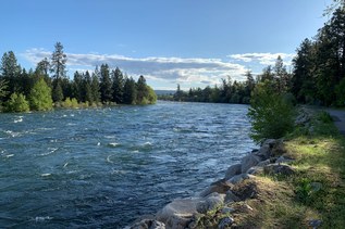
Start out hiking through a gauntlet of sword ferns, into old-growth forest. The undergrowth is a variety of lowland vegetation, dominated by a robust growth of salal, and the way is pleasantly graded and shaded. Your surroundings are so quiet that you can often hear recreational activity on Lake Crescent, and even vehicular traffic across the lake, a mile distant.

At 1.7 miles is the infamous slide area. For just over 100 yards, the trail passes laterally across a slope prone to frequent slides. Even in the best of conditions, the soil can be loose and treacherous, with tiny pebbles that skitter away underfoot. Crossing should never be attempted in wet or icy conditions. It is best to check recent trip reports ahead of time, to learn current conditions of the slide crossing. Wear proper footwear. A hiking staff or trekking poles are highly recommended.

Once across the slide area, follow some tight switchbacks up, then resume the previous moderate slope. At 2.5 miles, the trail breaks out into a plateau, having attained the ridge top. The final 0.9-mile remains mostly in forest, but allows a few peek-a-boo views as it follows the ridge to the top.

The top is occupied by a former lookout structure. This cabin was built during World War II, not as a fire lookout, but rather for the purpose of spotting enemy aircraft. Trees have grown tall enough to restrict the views from the top, but you can still see a lot of Lake Crescent, at 596 feet deep, second only to Lake Chelan in this state. (The “official” depth of 624 feet is in error.) To the east, you can see Lake Sutherland, separated from Lake Crescent by a low finger of land, the remnants of a landslide credited for forming Lake Crescent some 8,000 years ago. To the south, look over Crescent Lake Lodge into the heavily wooded Barnes Creek drainage.

Although the trail is managed by Olympic National Park, no parking permit or entry fee is required.

Dogs are not allowed on this trail, but are welcome on the wheelchair-friendly Spruce Railroad Trail, which intersects the trailhead.

WTA worked here in 2021, 2019, 2018, 2017, 2016, 2015 and 2014!

Hike Description Written by
Ken Giesbers, WTA Correspondent

Pyramid Mountain / Pyramid Peak

Map & Directions

Trailhead
Co-ordinates: 48.0662, -123.8594 Open in Google Maps

Before You Go

See weather forecast

Parking Pass/Entry Fee

None

WTA Pro Tip: Save a copy of our directions before you leave! App-based driving directions aren't always accurate and data connections may be unreliable as you drive to the trailhead.

Getting There

Drive US 101 west of Port Angeles, or north and east of Forks, toward Lake Crescent. At the very western end of Lake Crescent, turn northeast on Camp David Jr. Road (just west of milepost 221).

Continue straight on North Shore Road, following signs for 3.1 miles. The first half is paved, and the second is graded crushed rock. At 3.1 miles, look for a yellow pedestrian crossing sign. There is no parking lot per se, just designated handicapped parking on the right shoulder, and room for a few vehicles on nearby shoulders. There are no trailhead amenities. No parking pass is needed.

More Hike Details

Trailhead

Olympic Peninsula > Northern Coast

Pyramid Peak Trail (#866)

Olympic National Park

Guidebooks & Maps

Day Hiking: Olympic Peninsula (Romano - Mountaineers Books)

Olympic Mountains Trail Guide: National Park & National Forest 3rd Edition - #3

Custom Correct Lake Crescent-Happy Lake Ridge

Buy the Green Trails Lake Crescent No. 101 map

Download a map to plan your hike

You can improve or add to this guidebook entry!

Pyramid Mountain / Pyramid Peak

111 Trip Reports

Hiked here recently?

Submit a trip report!
 
Trip Reports