Cerro Mercedario
January 11-20, 2020
6720m
Barreal / San Juan, Argentina
Cerro Mercedario locates in the central Andes, in San Juan province of Argentina not far from the Chilean border. The exact elevation is somewhat arbitrary as different sources indicate it’s likely somewhere between 6700 m and 6770 m. It seems like around 6720 m is more accepted in at least the English-speaking countries, which places this peak as the 8th highest in South America. This peak locates only about 100 km north of Aconcagua and boasts a lot of similarities with the taller neighbour. They both have a shear, technical south face but also a “standard route” that in the right conditions, is nothing fancier than “class 1 walk-up”. Because of the drier climate, the standard route (Inca Route) on Mercedario might not touch snow at all in the summer seasons. This doesn’t mean these 6000 m Andes peaks are easy as the altitude and the weather (mostly due to high winds) still deserve a lot of respect and climbing these peaks are still very physically demanding. Comparing with Aconcagua, Mercedario has a shorter approach but a much more remote feeling. There is no crowds, no regulation nor permit required, but the logistic complications of getting to the start of the trek can sometimes be a major hassle, especially for foreigners.
A few months ago Connor McEntee invited me to climb two of the world’s top 100 peaks by prominence in the Andes – Ojos del Salado and Mercedario, with Alaskan climber David Hart at the beginning of the new year. At that time I was still “in” for a mission to climb some Ecuadorian volcanoes but that trip quickly fell apart. I agreed to join even though my priority wasn’t the prominence list, but rather to climb above 6000 m elevation. I had bigger plans about the Himalayas and I needed to familiarize myself with the fundamentals of high altitude climbing. This trip sounded like a perfect introductory as both Ojos del Salado and Mercedario are non-technical with little to worry about beside the weather and altitude. One might ask why not climbing Aconcagua and the answer is very simple – both partners of mine had already climbed it… David Hart has arguably one of the most prolific peak-bagging resumes online, having climbed far more peaks in Alaska/Yukon than probably anyone else and also Broad Peak without oxygen nor guide, so we had a very strong team. Connor did all of the research, planning and the logistics and the plan was to climb Mercedario first, using this peak as acclimation ground in order to climb the high peaks in Atacama in a smash-and-grab fashion. Connor and I would stay in the Andes for exactly a month but Dave had to leave one week before us. Aside from the two main objectives we also wanted to climb Marmolejo, the southernmost 6000 m peak on Earth, as well as more 6000 m volcanoes around, and to the north of Ojos del Salado. We would stay on Mercedario until weather allowed us to climb it, and there was no specific sequence as which peak(s) we would climb next after Mercedario. Aside from the first few days the exact itinerary would be determined purely based on weather and how we felt, at the very last minute. The reason is simple as we wanted to maximize our chance of success on each of these climbs.
For the logistics and transportation from Mendoza, Argentina to the trail-head at Laguna Blanca we picked Grajales. Although significantly more expensive than its competitors this is the biggest logistic company out there and seemed much more responsive in communication. The ride would be over 5 hours by truck. Connor flew to Mendoza a few days prior to the trip to sort out a few more things while Dave and I booked a series of connecting flights over Jan. 9 and 10. We would depart Mendoza on Jan. 11 leaving no room of error in these flights, which seemed like a risky decision. It turned out both my Air Canada flight to Los Angeles and the LATAM flight to Santiago, Chile were delayed, but thankfully caused no issue. On the bright side, it proved again that obtaining a window seat is very worthwhile. Dave and I arrived in Mendoza in the morning of Jan. 10, took a taxi to Fuente Mayor Hotel in the downtown where we grouped with Connor. The three of us then spent the rest of this day shopping in the city for food and fuel.

The southern Olympics seen from the Air Canada flight YVR to LAX

The Three Sisters and Mt. Bachelor in central Oregon

Flying over the Andes on LATAM flight SCL to MDZ. Volcan San Jose at center.

Volcan Tupungato dominates the skyline right of center

Our first meal in Mendoza also my first meal in South America

Exploring the city in the evening. This is the time when people actually go out.
Carlos from Grajales showed up at 10 am and helped us loading all of the heavy shits into his Toyota Hilux and we were soon on the roads. We drove up following Rio de Mendoza to Uspallata where we took the lunch break. We all stuffed in plenty of empanadas and resumed the northwards drive towards San Juan province border. The road apparently doesn’t see much traffic as the Mendoza side of the border becomes unpaved for a long stretch. Into San Juan province we didn’t have to go actually into the town of Barreal to turn onto the mining roads following Rio de Los Patos and then Rio Blanco, slowing working our ways towards the north-east flanks of Cerro Mercedario. We learnt that the bridge over Rio Colorado was washed out but recently repaired. We were very lucky as a downed bridge could have ruined the whole trip. The last few miles leaving Rio Blanco towards Laguna Blanca was narrow and steep, but not as rough as some sources indicated. Carlos dropped as at the refugio a few kilometers past Laguna Blanca, at around 3150 m. This refugio was apparently constructed for mining purposes, but nowadays is more often used as a staging area for climbers. The elevation of this refugio served perfectly as the first night for acclimation so we spent the next few hours hanging around. The only downside was the lack of (clean) water sources. I made a mistake for not bringing extra water and was forced to drink most of my Gatorade, that was supposed to be brought to basecamp for luxuries.

Carlos came to pick us up from the hotel

Great scenery on the dirt roads following Rio de Los Patos

Horses are common in this area

The three of us plus Carlos at the refugio drop-off
On this particular ascent we actually hired two mules to transport our gears from the trail-head to basecamp at 4380 m. The mules could only help our approach but not the exit so despite the luxuries we still had to be careful about weight, as we had to pack out everything that we brought in. The cost of the mules was 640 US dollars for the group, and the additional cost of using Grajales was something around 1300 dollars. It was Grajales that communicated with the mules and we all had concerns whether or not the mules would show up on time. It turned out that they even showed up before the scheduled arrival and quickly loaded up our shits. The objective of the first approach day (Day 2 since leaving Mendoza) was an intermittent camp called Guanaquitos, at 3800 m elevation. The distance was less than 4 km and took us under 2 hours on a very leisure pace. The mules would stay with us to spend a night at the camp as well. Connor and I were bored in the hot afternoon and went for a walk exploring a side valley towards Cerro Don Antonio. Back to camp the three of us decided to open bivy in order to save work from unnecessary transitions.

Cerro Mercedario Ruta Normal. GPX DL

Looking back towards the flats above Laguna Blanca at the trail-head

Connor starting the hike

Me and Dave starting the hike. Photo by Connor M.

This was my first time seeing guanacoes

Dave plodding up with the dry flats by Laguna Blanca behind

The mules passes us near Guanaquitos camp

Fresh and clean water sources at this camp

Guanacoes and Cerro Mercedario

Open bivying at night instead of pitching the tents.
The mules guys told us to get going at 7 am in the morning which seemed a wee bit too early. We figured that they probably wanted to go home as soon as the job’s done, so reluctantly agreed. Connor had concerns that they might drop the two green boxes at Cuestas Blancas (base camp) in additional to our food. We would not want to carry the two boxes out plus we also had trash from the first two days to let the mules to carry out. Connor was definitely the fastest among us and volunteered to start half an hour earlier to beat the mules. Dave and I would resume our leisure pace and were passed by the mules about halfway up. Another hour or so later on the steep switchbacks right below Cuestas Blancas we met the two mules trekking out, carrying both boxes which was good. The rest of the hike to the camp sites was uneventful but seemed to drag on longer than expected. The original plan was to hike back to Guanaquitos to sleep but we all felt decent about the altitude so opted to skip a day by sleeping directly at 4380 m elevation on Day 3.

Early wake-up on Day 3

Halfway up the valley towards Cuestas Blancas we were still in shade

Dave ascending into sunshine and it became hot in no time

The typical scenery on this stage

The first mule came down already

The second mule came down carrying our trash and green boxes.

One last photo of the mules. They wouldn’t be here to help our exit

Dave arriving at Cuestas Blancas (base camp)

Our two tents at Cuestas Blancas
Day 4 was supposed to be a “rest day” but none of us wanted to hang around the camp for the whole day, and the new decision was to carry part of the weight and cache somewhere between Cuestas Blancas (4380m) and Pircas de Indios (5150m). After a leisure morning we all packed about 8-10 kg of load and the goal was to at least drop them above the “bowl” behind Cuestas Blancas. This meant at least 300 m elevation gain. The trail leading up to and out of the steep bowl was better than expected and we then decided to continue to Pircas de Indios. The ascent to this next campsite involved another 500 m elevation gain but with a much gradual grade, and therefore much longer distance and took another two hours or so. We rested at the Indios (5150 m) for about an hour and then Connor and I went for a sidewalk to get fresh water under the nearby glacier. There was no (clean) water source at Cuestas Blancas and collecting water from the tiny streams had proven to be somewhat difficult, so we each loaded about 3L of fresh water before leisurely heading down. We debated about excelling another day ahead of schedule but opted to take the acclimation process more conservatively. On Day 5 we repeated what we just did on Day 4, carrying about 10 kg of load to Pircas de Indios. Connor felt exceptionally strong and continued to carry some group gears onto La Hoyada (5650m) while Dave and I went to get water and then headed down to Cuestas Blancas. On Day 6 we moved up to Pircas de Indios and completed our “triple carry” to this camp, slowly but steadily.

Dave slowly but steadily marching up the big hill above base camp

Pircas del Indios is still a long ways away

Connor went for this “small” glacier to explore water situation

We found running water in this gully

Connor and Glacier Pircas del Indios

Another photo of the glacier. The photo fails to illustrate the scale of it

One last photo before heading back to base camp

Lenticular clouds indicated it was windy at higher altitude

The typical choss descent to base camp

Dave and Connor above base camp

Back to base camp after completing the first of the three carries

There was a huge thunderstorm not too far from us that night

Me at the glacier on the second carry

Dave hiking back to camp after the second carry

Burning trashes

Dave and Connor on their third carry to Pircas del Indios.

Dave near the end of the third carry.

Our tents at Pircas del Indios.
Day 7 saw some nice weather and we waited until almost 10 am to get going. The objective was to complete the first of the two carries to La Hoyada (5650 m). I decided to carry all of my high altitude gears except for boots up to the high camp as the weather seemed nice enough that I was sure those mitts and goggles wouldn’t be needed in the next day or two. Pircas del Indios was located in another but flatter bowl so the ascent once again, involved climbing out of a scree bowl onto the ridge above it. The view from this stage was much more expansive that we started to see the Cordillera de Antisilla that has 7 peaks in the 5000 m range behind us. There wasn’t significant wind at La Hoyada so we hung around for a while. The only group at the high camp was packing up after a failed attempt and said the wind was “too cold” and they were fearing to lose fingers. That sounded unpleasant but such wouldn’t be a concern for me because I brought mitts (Mountain Hardwear Absolute Zero) that were designed to handle Denali and Mount Everest… Dave headed down and Connor opted to hang around to kill time. I decided to hike a short ways to 5700 m elevation break my previous elevation record, and then we all headed down to Pircas de Indios to sleep. On Day 8 we completed the second carry to La Hoyada and hung around at camp. There was clean water under Hoyada Glacier so for the whole trip we did not have to melt snow for a single time.

Starting the first carry to La Hoyada

Starting to see more and more of the central Andes

Connor and a subsidiary highpoint that we tempted to ascend.

Cresting the ridge we got to see the SW side all the way down towards Barreal

Antisilla Range Peak #7 and Laguna Blanca also visible

Almost at La Hoyada

Dave arriving at the high camp

More cool clouds formation. This was not a good day to attempt summit

Dave went to get some water. Lenticular clouds captured the summit

Another photo of Antisilla range Peak 7

I went to hike to 5700 m to break my own elevation record.

From my highpoint I took this photo looking down south

This was the second carry to La Hoyada

The weather became stormy in the afternoon

The two Argentinians arrived at the high camp a few hours later

We had to hide in tents for several hours to ride out of a series of storms

The storms passed

Some cool lightings in the evening

The last bit of sun ray on Cerro Wanka and Cerro Friuli

Stormy weather still lingered on Antisilla Range peaks
The wind and temperature was downright pleasant at night especially considering the altitude. I didn’t even bother to store the water bottles in the sleeping bag although they did start to freeze a little bit. It’s also worth nothing that for the whole ascent I didn’t even need to zip up my sleeping bag (Western Mountaineering -32 C) as this bag was a total overkill for this whole trip… The altitude did make sleeping difficult but it could also due to the excitement of the summit day ahead. I managed to sleep probably 1-2 hours intermittently. At 4 am I heard noises from the nearby Brazilian and Argentinian groups. Dave and I opted to start shortly after while Connor would sleep for another hour. The initial 200 m out of La Hoyada was confusing cross-country on scree but with the others headlamps guiding the way we quickly gained the trail. Connor caught up with us in no time. The next stage was a gradual ascent on zig-zagging trail to some rock towers followed by a large flat spot known as El Diente at 6100m. By this point we had passed everyone else and the sky’s gradually becoming brighter. We also entered some mist as the uber-long rising traverse started on the north side of the NE Ridge. This rising traverse would last all the way to within 200 vertical meters from the summit before making a direct attack to the true summit. We started to encounter fresh snow but no traction needed. There’s actually not much worth noting other than the need of extreme endurance and patience. I actually felt the higher end of this ascent not nearly as miserable as people made it sound and it was definitely not “three breathes per step”. For the last 100 m gain I took over the trail-breaking and dashed for the summit. The view suddenly became extremely dramatic with thousands of meters of vertical relief towards all directions and to our surprise, the wind died down just 5 meters south of the apex giving us a pleasant stay to soak in the views. Marco from Argentina joined us 5 minutes later.

We started a few hours before sunrise and it was windy and cold…

Above 6100 m elevation now.

We were high above Hoyada Glacier now

Unfortunately the ascent was mostly in shade and not pleasant

Connor marching up. Note the fresh snow from the day before

Finally hiked into sunshine but at 6500 m it was still cold…

Dave leading the way

Connor and Dave plodding up

Higher than everything

Upwards and onward. I went ahead with still over 100 m of gain

La Mesa covered in lenticular clouds as I popped onto the summit

La Ramada is another fabled 6000 m peak in this region

Some of the typical Andean scenery in this area, to the west in Chile

Aconcagua to the south almost looked like a very tall piece of cloud

Dave approaching the summit

The sun suggested we were still early in the day

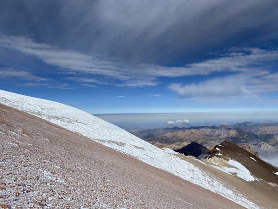
A wider view looking south with dramatic vertical relief

Another photo of La Mesa

The town of Barreal somewhere in the plain, 5000 vertical meters down

The huge ass SW Face drops 3000 meters down

Me on the summit of Cerro Mercedario, the 8th highest in South America

Partial Summit Panorama from Cerro Mercedario. Click to view large size.

Connor taking in the views

Connor and I on the summit of Mercedario.
On the descent we passed the rest of the gang on the last 200 m elevation gain and it turned out that all 7 of us summitted Mercedario on this day. On the descent we agreed to explore a lower set of “trails” on the traverse sections as it appeared more direct. This turned out to be a not-so-great call. The trail disappeared at about 100 m above Hoyada Glacier and to regain the standard route we had to traverse at least one kilometer of horrible moraine and scree. Connor went far ahead and cleared the misery while Dave and I were determined to find a way getting onto the glacier. The problem was, none of us brought crampons and ice axe and the edge of the glacier appeared to have some blue ice. We did manage to find one spot to get on after some 3rd class down-climbing and some precise footwork tip-toeing on ice. Marco and the Brazilian followed, attempted to get onto the glacier but failed. They had to do some frustrating work traversing back to the standard route. For Dave and I, the descent of Hoyada Glacier was far worse than appeared with at least one horizontal kilometer of penitentes. It proved to be an interesting variation but not without difficulty. Half an hour after getting back to camp it started to thunder and then pour. The two Argentinians got lost in the storm but did manage to arrive safely, albeit soaked. The original plan was to descend partway but given the weather we opted to spend another night at the high camp. Meanwhile we inReached Grajales and confirmed a pick-up at 4 pm of the following day.

Connor heading down. (Dave left the summit as soon as he made there).

The other climbers were still going up
Can’t stop taking photos of the high Andean scenery

Catching up with Dave and we took a different line down

Careful scrambling to get onto the icy Hoyada Glacier

Dave in the zone of penitentes nightmare. It was painful to say the least.
In the morning of Day 10 we shouldered the heavy pack and descended to Pircas de Indios where we picked up more loads. The next stop was at Cuestas Blancas another hour or so later where unfortunately, we had to load up more shits. My pack was probably 40 lb when we left Cuestas Blancas and Dave’s probably at least 60 lb… The descent to Guanaquitos was scenic but longer and rougher than when I remembered from a week ago. We took a long break at the 3800m-Guanaquitos camp to cook some food before committing to the final descent back to the refugio. The last stretch was on mining roads and was pretty easy. We finished the hike at around 2 pm. At around 3 pm a truck showed up and it was Nuria from Grajales picking us up. Nuria is a local mountaineer based in Barreal with a ton of knowledge about the Argentinian Andes and we had some very fun conversations during the 5-hour ride back to Mendoza. For the dinner we went to La Barra per Nuria’s suggestion for a huge ass steak.

Sunrise on the morning of Day 10 the day we descended all the way to Mendoza…

Connor ready to leave La Hoyada

Connor and Antisilla range Peak #7

Another photo of Connor and the Antisilla Range peaks

Yet one more photo of Connor descending towards Pircas del Indios

The bright morning sun behind Cerro Wanka et al.

Connor still on the descent to Pircas del Indios

Fast forward. We were at Cuestas Blancas now

Dave’s pack was at least 60 lb at this point.

Descending the scenic valley towards Guanaquitos

Started to see some greens after being in the alpine for a week

Down to the old mining road now

A review shot of Cerro Mercedario

Back to the refugio

Nuria came to pick us up

Driving down the steep switchbacks below Laguna Blanca

Crossing the raging Rio Colorado. The bridge was down not long ago

This zone has lots of secret rock climbing for local Barreal mountaineers

It was pouring cats and dogs in Mendoza

We had some huge steaks in the restaurant La Barra
We had one rest day in Mendoza. The morning was spent sorting logistics out and changing plans. The weather was calling for over a meter of snow in Ojos del Salado area over the next few days and we cancelled everything including our flights to Copiapo. The new plan was to climb Marmolejo first where the weather was stellar. The last minute flight to Santiago was too expensive but we could also take a bus there. In the afternoon we went for some shopping as we planned to do all the prep work here in Mendoza rather than in Santiago. For the night we went for a different restaurant for more steak and I have to say the Argentinian steak lives to its reputation.

Mendoza has gear stores commercialized for Aconcagua

Exploring the downtown

Wine that came out of Nuria’s farm. I bought it.

Our last dinner in Mendoza before heading into Chile…
Cerro Mercedario is often overlooked due to the proximity to Aconcagua but for those that don’t “have to” climb the #1 in South America this peak provides a much cheaper and less crowded alternative. Not to mention that Aconcagua is also heavily regulated. Mercedario is only 200 m lower in altitude but offers similar Andean experience in many ways and I would definitely recommend.
List of gears I brought.
- Mountain Hardwear BMG 105L pack
- Western Mountaineering Puma GWS -32C sleeping bag. Total overkill, should have gone with around -18C…
- Scarpa Phantom 6000 boots – used above 5200m.
- Salomon trail shoes – used below 5200 m and the first carry to 5650 m.
- XTherm sleeping pad
- Single-wall 4-season tent – shared with Connor
- MSR XGK white gas stove
- Mountain Hardwear Absolute Zero Mitts – used for 10 minutes on the summit… Otherwise, MEC Overlord gloves was warm enough…
- WileyX Goggles – used on the summit day
- Julbo Glacier Glasses
- iColor 360-degree sun hat – also used as a balaclava..
- MEC Storm-degree Parka – used on the summit day, and also as a pillow…
- Balaclava – not used..
- Down pants – not used…
- Aluminum ice axe – left at base camp
- Petzl Irvis Hybrid crampons – left at base camp
